文件:EU Member states and Candidate countries map.svg

此SVG文件的PNG预览的大小:701 × 599像素。 其他分辨率:281 × 240像素 | 561 × 480像素 | 898 × 768像素 | 1,198 × 1,024像素 | 2,395 × 2,048像素 | 1,401 × 1,198像素。
原始文件 (SVG文件,尺寸为1,401 × 1,198像素,文件大小:860 KB)
Saegmangj
| 描述 |
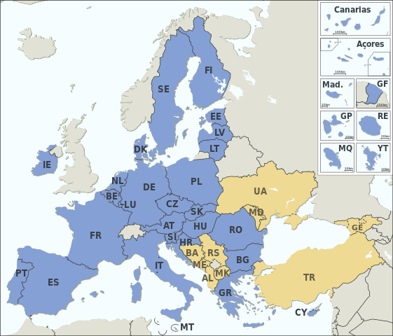
Asturianu: Estaos miembros de la XE (más los países candidatos)
Català: Estats membres de la UE (més els països candidats)
Deutsch: Mitgliedstaaten der EU (+ Bewerberländer)
English: Member states of the EU (plus candidate countries)
Esperanto: Membraj ŝtatoj de EU (kaj kandidataj landoj)
Español: Estados miembros de la UE (más los países candidatos)
Français : Etats membres de l’UE (et pays candidats)
Italiano: Stati membri dell’UE (+ Paesi candidati)
Македонски: Земји членки на ЕУ (+ кандидати)
Member states of the EU Candidate countries
|
|||||||||||||||||||||||||||||||||||||||||||||||||||||||||||||||||||||||||||||||||||
| 日期 | ||||||||||||||||||||||||||||||||||||||||||||||||||||||||||||||||||||||||||||||||||||
| 来源 |
Natural Earth 1:50m (http://www.naturalearthdata.com) |
|||||||||||||||||||||||||||||||||||||||||||||||||||||||||||||||||||||||||||||||||||
| 作者 | Alexrk2 | |||||||||||||||||||||||||||||||||||||||||||||||||||||||||||||||||||||||||||||||||||
| 其他版本 |
|
|||||||||||||||||||||||||||||||||||||||||||||||||||||||||||||||||||||||||||||||||||
| SVG开发 |


许可协议
我,本作品著作权人,特此采用以下许可协议发表本作品:
本文件采用知识共享署名-相同方式共享 3.0 未本地化版本许可协议授权。
- 您可以自由地:
- 共享 – 复制、发行并传播本作品
- 修改 – 改编作品
- 惟须遵守下列条件:
- 署名 – 您必须对作品进行署名,提供授权条款的链接,并说明是否对原始内容进行了更改。您可以用任何合理的方式来署名,但不得以任何方式表明许可人认可您或您的使用。
- 相同方式共享 – 如果您再混合、转换或者基于本作品进行创作,您必须以与原先许可协议相同或相兼容的许可协议分发您贡献的作品。
文件历史
点击某个日期/时间查看对应时刻的文件。
| Ngoenz/Seizgan | 缩略图 | 大小 | Bouxsawjyungh | Gejgangj | |
|---|---|---|---|---|---|
| seizneix | 2024年1月31日 (Sam) 17:11 | | 1,401 × 1,198(860 KB) | Janitoalevic | Armenia-Azerbaijan update |
| 2023年12月15日 (Ngux) 00:27 |  | 1,401 × 1,198(860 KB) | Iktsokh | Georgia is recognized as an official candidate. | |
| 2023年2月6日 (It) 16:12 |  | 1,401 × 1,198(860 KB) | Nestrus | forgot the caption | |
| 2023年2月6日 (It) 16:07 |  | 1,401 × 1,198(859 KB) | Nestrus | +candidate Bosnia | |
| 2022年6月23日 (Seiq) 18:58 |  | 1,401 × 1,198(845 KB) | Cyygma | Ukraine and Modova confirmed as official candidates | |
| 2020年2月1日 (Loeg) 15:13 |  | 1,401 × 1,198(844 KB) | Hansbaer | absurd argument. The map has always followed the development of the EU | |
| 2020年2月1日 (Loeg) 14:48 |  | 1,401 × 1,198(845 KB) | Alexis Jazz | Reverted to version as of 16:53, 17 March 2015 (UTC) User:Janitoalevic needs to be uploaded as a new file | |
| 2020年1月31日 (Ngux) 23:15 |  | 1,401 × 1,198(844 KB) | Janitoalevic | Brexit | |
| 2015年3月17日 (Ngeih) 16:53 |  | 1,401 × 1,198(845 KB) | Appaches | Ukraine-Crimée : séparation pointillée | |
| 2015年3月15日 (Ngoenz) 17:05 |  | 1,401 × 1,198(844 KB) | Appaches | Islande retirée |
文件用途
以下页面使用本文件:
全域文件用途
以下其他wiki使用此文件:
- ab.wikipedia.org上的用途
- ar.wikipedia.org上的用途
- ast.wikipedia.org上的用途
- az.wikipedia.org上的用途
- az.wiktionary.org上的用途
- be-tarask.wikipedia.org上的用途
- br.wikipedia.org上的用途
- ca.wikipedia.org上的用途
- cy.wikipedia.org上的用途
- da.wikipedia.org上的用途
- de.wikipedia.org上的用途
- Europäische Union
- Portal:Europäische Union
- Mitgliedstaaten der Europäischen Union
- Gebiet der Europäischen Union
- Vorlage:Imagemap Mitgliedstaaten der Europäischen Union
- Vorlage:Imagemap Mitgliedstaaten der Europäischen Union/Test
- Wikipedia:Kartenwerkstatt/Archiv/2011-04
- Benutzer:RickVulcan/Länder Europas
- Extrempunkte der Europäischen Union
- Benutzer:Kpfiwa/Spielwiese/Test
- Benutzer:Oesterreicher12/Spielwiese 2
- Benutzer:HudecEmil
- de.wiktionary.org上的用途
- ext.wikipedia.org上的用途
- fiu-vro.wikipedia.org上的用途
- fo.wikipedia.org上的用途
- frp.wikipedia.org上的用途
- fr.wikipedia.org上的用途
- Élargissement de l'Union européenne
- Droit européen
- Utilisateur:William Pedros
- Modèle:UE-EU-ISO 3166-1 530px
- Union européenne
- Futur élargissement de l'Union européenne
- Wikipédia:Atelier graphique/Cartes/Archives/mai 2014
- Wikipédia:Atelier graphique/Cartes/Archives/mars 2015
- Utilisateur:AlexisN
- Wikipédia:Atelier graphique/Cartes/Archives/août 2017
- fr.wikibooks.org上的用途
- fur.wikipedia.org上的用途
- fy.wikipedia.org上的用途
- gd.wikipedia.org上的用途
- he.wikipedia.org上的用途
- hr.wikipedia.org上的用途
- hu.wikipedia.org上的用途
- hy.wikipedia.org上的用途
- ia.wikipedia.org上的用途
查看本文件的更多全域用途。